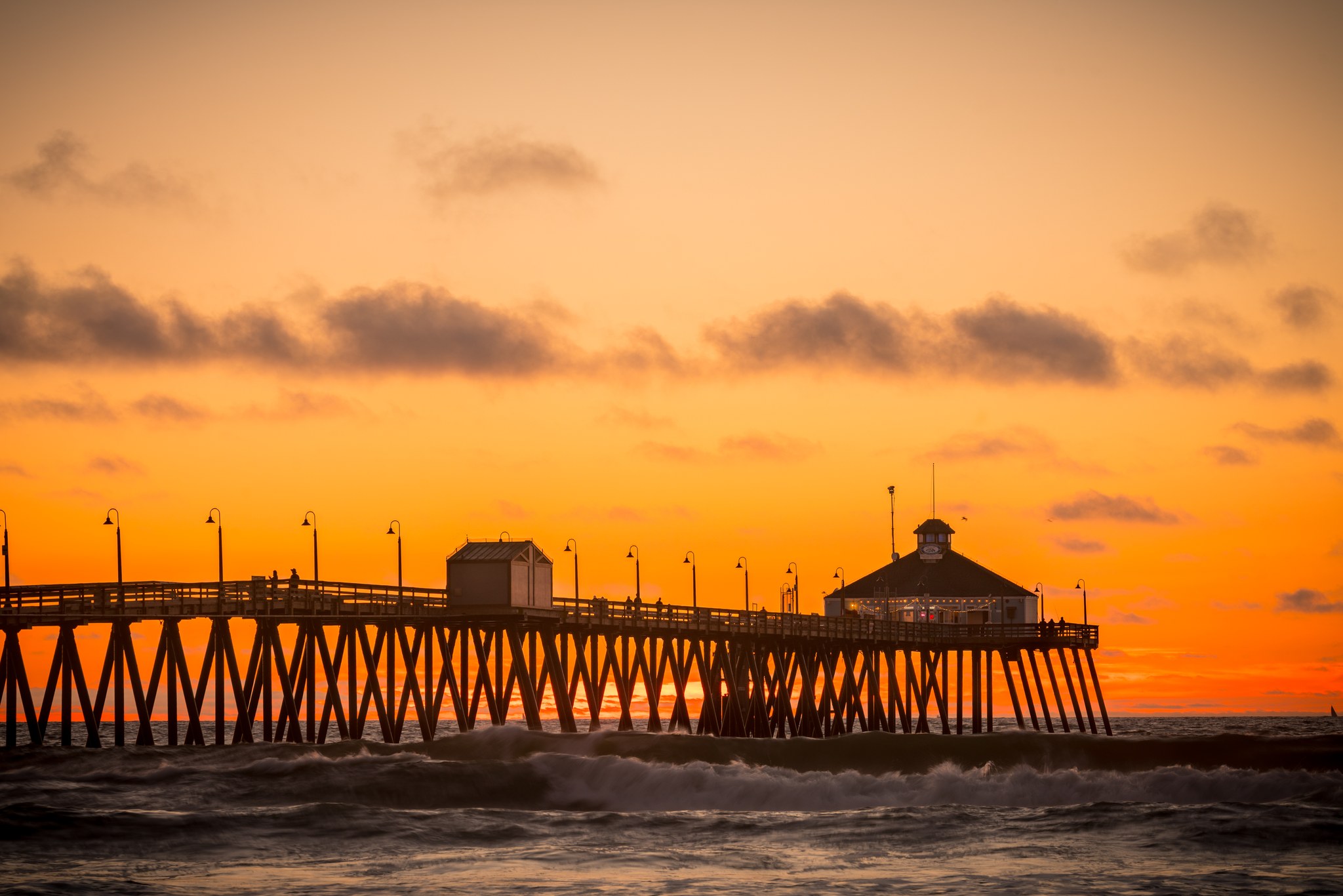
Imperial Beach Pier at sunset, photographed in 2017.

Outdoors

Wildlife viewing and birding near Imperial Beach

Refuges, lakes and wild areas near Imperial Beach for wildlife viewing and birdwatching.

19places to see wildlife
1 mito the closest
4within 30 miles

Good to know: Early mornings and evenings are best for wildlife; bring binoculars and keep a respectful distance.

Closest picks

1

Tijuana River National Estuarine Research Reserve

1 mi southwest · National Oceanic and Atmospheric Administration

The Tijuana River National Estuarine Research Reserve preserves one of the largest remaining examples of coastal wetland habitats in the southern California sub-region.
2

San Diego Bay National Wildlife Refuge

4 mi north · Fish and Wildlife Service

San Diego Bay National Wildlife Refuge The San Diego Bay National Wildlife Refuge protects a rich diversity of endangered, threatened, migratory, and native species and their habitats within a highly urbanized coastal environment.

3

Cabrillo National Monument

10 mi northwest · National Park Service

In 1542, Juan Rodriguez Cabrillo climbed out of his boat and onto shore, becoming the first European to set foot on what is now the West Coast of the United States.

Map of all 19 places

Map of 19 places loads as you scroll.

Within 30 miles (4)

1 mi southwest · National Oceanic and Atmospheric Administration

Tijuana River National Estuarine Research Reserve

The Tijuana River National Estuarine Research Reserve preserves one of the largest remaining examples of coastal wetland habitats in the southern California sub-region.

  • Paddling
  • Photography
  • Ranger programs
  • Swimming
  • Wildlife viewing

4 mi north · Fish and Wildlife Service

San Diego Bay National Wildlife Refuge

San Diego Bay National Wildlife Refuge The San Diego Bay National Wildlife Refuge protects a rich diversity of endangered, threatened, migratory, and native species and their habitats within a highly urbanized coastal environment.

  • Birding
  • Fishing
  • Motor Boat
  • Wildlife viewing

10 mi northwest · National Park Service

Cabrillo National Monument

In 1542, Juan Rodriguez Cabrillo climbed out of his boat and onto shore, becoming the first European to set foot on what is now the West Coast of the United States.

  • Hiking
  • History
  • Wildlife viewing

16 mi east · Bureau of Land Management

Otay Mountain Wilderness

The Otay Mountain Wilderness has a total of 16,885 acres and is managed by the BLM's Palm Springs-South Coast Field Office .

  • Camping
  • Horseback riding
  • Photography
  • Wilderness
  • Wildlife viewing

30 to 75 miles (8)

38 mi east · USDA Forest Service · Campground

Boulder Oaks Eqst

Boulder Oaks offers equestrian and family sites in the scenic Cleveland National Forest, about an hour away from San Diego, California.

  • Backpacking
  • Birding
  • Camping
  • Hiking
  • Horse Camping
  • Horseback riding
  • Hunting
  • Picnicking

44 mi northeast · USDA Forest Service · Campground

El Prado Group

El Prado Group Campground is a great mountain getaway just one hour east of San Diego, California in the Laguna Mountain Recreation Area.

  • Biking
  • Birding
  • Camping
  • Cultural Activities
  • Hiking
  • History
  • Horseback riding
  • Information Site

44 mi northeast · USDA Forest Service · Campground

Horse Heaven Group

Contrary to its name, Horse Heaven Group Campground has no equestrian sites. Instead, this tent-only facility can accommodate gatherings of up to 100 people.

  • Biking
  • Birding
  • Camping
  • Hiking
  • Horseback riding
  • Mountain Biking
  • Scenic Drive
  • Wildlife viewing

47 mi east · Bureau of Land Management · Campground

Cottonwood Campground

Among the live oaks in southeastern San Diego County is Cottonwood Campground. The campground offers a tranquil and refreshing experience.

  • Biking
  • Camping
  • Hiking
  • Horseback riding
  • Hunting
  • Photography
  • Wildlife viewing

52 mi east · Bureau of Land Management

Carrizo Gorge Wilderness

The Carrizo Gorge Wilderness now contains a total of 14,741 acres and is managed by the Bureau of Land Management. All of the Wilderness is in the state of California.

  • Camping
  • Hiking
  • Photography
  • Wilderness
  • Wildlife viewing

65 mi east · Bureau of Land Management

Coyote Mountains Wilderness

The Coyote Mountains Wilderness now contains a total of 18,630 acres and is managed by the Bureau of Land Management. All of the Wilderness is in the state of California.

  • Camping
  • Hiking
  • Photography
  • Wilderness
  • Wildlife viewing

65 mi east · Bureau of Land Management

Jacumba Wilderness

The Jacumba Mountains Wilderness now contains a total of 31,357 acres and is managed by the Bureau of Land Management. All of the Wilderness is in the state of California.

  • Camping
  • Climbing
  • Hiking
  • Photography
  • Wilderness
  • Wildlife viewing

69 mi northeast · Bureau of Land Management

Fish Creek Mountains Wilderness

The Fish Creek Mountains Wilderness now contains a total of 21,388 acres and is managed by the Bureau of Land Management. All of the Wilderness is in the state of California.

  • Camping
  • Hiking
  • Photography
  • Wilderness
  • Wildlife viewing

75 miles and farther (7)

84 mi northeast · Bureau of Land Management

Santa Rosa Wilderness

The terrain within the Santa Rosa Mountains Wilderness is rugged with elevations rising dramatically from just above sea level to 7,000 feet.

  • Camping
  • Hiking
  • History
  • Horseback riding
  • Hunting
  • Photography
  • Wilderness
  • Wildlife viewing

86 mi northeast · Bureau of Land Management

Palms to Pines Scenic Byway

This scenic driving tour climbs from the desert through the Santa Rosa and San Jacinto Mountains, before descending again to the desert.

  • Photography
  • Picnicking
  • Wildlife viewing

95 mi northeast · Bureau of Land Management

Dos Palmas Preserve

This oasis with its hundreds of swaying fan palms offers sanctuary in the midst of the dry Colorado Desert. Pools fed by artesian springs and seepage from the nearby Coachella Canal form a lush wetland area.

  • Hiking
  • Photography
  • Wildlife viewing

95 mi north · US Army Corps of Engineers

Prado Dam

This San Bernardino County Parks managed area is an oasis within one of the fastest growing areas of Southern California. Riverside County and the City of Corona also provide recreation facilities.

  • Boating
  • Camping
  • Horseback riding
  • Picnicking
  • Water sports
  • Wildlife viewing

97 mi northeast · Bureau of Land Management

Mecca Hills Wilderness

The Mecca Hills Wilderness now contains a total of 26,242 acres and is managed by the BLM's Palm Springs-South Coast Field Office . All of the Wilderness is in the state of California.

  • Camping
  • Hiking
  • Photography
  • Picnicking
  • Wilderness
  • Wildlife viewing

100 mi northeast · Bureau of Land Management

Orocopia Mountains Wilderness

The western boundary of the Orocopia Mountains Wilderness is contiguous with the Mecca Hills Wilderness with the exception of the Meccacopia Jeep Trail, which bisects the two wilderness areas.

  • Camping
  • Hiking
  • Horseback riding
  • Hunting
  • Photography
  • Wilderness
  • Wildlife viewing

101 mi northwest · US Army Corps of Engineers

Carbon Canyon Dam

Managed by Orange County, there is no permanent pool, but varied facilities such as fishing, picnic areas, a nature trail, and tennis. The site of the historic oil boom town of Olinda. Adjoins Chino Hills State Park.

  • Fishing
  • Hiking
  • Picnicking
  • Wildlife viewing

Distances are straight-line miles from downtown Imperial Beach. Listings come from Recreation.gov’s federal recreation database; check each official page for hours, fees, fire restrictions and closures before you go.

Get outside around Imperial Beach

Around Imperial Beach

Coronado Beltline, Imperial Beach
Coronado BeltlineRightCowLeftCoast · CC BY-SA 4.0
Imperial Beach photograph by Roman Eugeniusz
Imperial Beach, CA, USA (6)Roman Eugeniusz · CC BY-SA 3.0
Imperial Beach, California The symbol of this surfers' community south of San Diego
Imperial beach ca 1Kotoviski photographed by Henryk Kotowski · CC BY-SA 3.0

More outdoors near Imperial Beach

Questions

Where is the closest place for wildlife & birding near Imperial Beach?

Tijuana River National Estuarine Research Reserve (National Oceanic and Atmospheric Administration), about 1 miles southwest of Imperial Beach as the crow flies. Next are San Diego Bay National Wildlife Refuge (4 mi) and Cabrillo National Monument (10 mi).

Who manages these places?

Federal agencies including Bureau of Land Management, USDA Forest Service, US Army Corps of Engineers. Each listing links to its official page for hours, fees, closures and current conditions.

Imperial Beach AI

Your Imperial Beach local guide
Hey there!

I'm Imperial Beach AI. Ask about local food, shopping, history or a day out.

AI recommendations may be inaccurate. Verify hours and prices. Questions are processed by Cloudflare. Privacy